
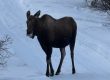
On our way home Sunday, J & I hiked to the highest point in CT, which is on the way up Mt. Frissell (in Mass) at a whopping 2,380 feet.
 This was a nice, short hike (3ish miles), but it was hotter than hell. This was our 10th high point. Sometimes finding the trailhead to the high point is the hardest part and this was no exception. The trailhead was tucked deep in the woods of CT (so much so that you didn’t even know you were still in CT) and did not have any signage. So it took some guesswork. But it all worked out.
Here’s another example about difficulty in getting to a high point. J & I are flying out to Chi-town tomorrow. We booked the annual Mother’s Day trip with one extra day so we could hit Charles Mound, the “high” point of IL. We started planning the specific logistics this week and found out the property owners (the high point is on private property) have restricted access to only 8 days a year. Do you think those 8 days include Thursday, May 6? Nope.
Discover more from Wandering La Vignes
Subscribe to get the latest posts sent to your email.


So, how tall is this high point?
If Topeka is in our future and you come to visit, reaching the "high" point there won't be worth your time I'm afraid. You and J could try riding some tornadoes though!
Gerald, this one was at 2,380, with about 1,000 feet of elevation change. Most of the East coast HPs are under 6,000 and have some sort of elevation change, whereas the Midwestern ones are just rolling hills. And it's the West coast that gets dicey!
Shayna, yes, the HP in Kansas is just a hill, but it's 5 hrs west of Topeka, so no help in you living there!! I'll still come and visit and have my video camera ready for the tornadoes!!